Sunday 18 December 2016

From Romans to Witches - Grimeshaw Lane


It is fair to say that, at the moment, the outskirts of Lancaster do not look very pretty. The hillsides have fresh scars slashed across them as construction work continues on the M6-Heysham link road.

But, just a very short distance from there, I met a friend, who took me along one of her favourite walks.


Sometimes, history is not visible. Castles, stately homes, archaeological remains - all give us a link to the past which we can see, and hope to understand. At other times, we can only get a sense of what has gone before, and interpret as best we can what is left in our modern world. This makes such places much harder to protect, but it is no less important that we attempt to do so.


A determined group of people just outside Lancaster are trying, at the moment, to do just that, and to save Grimeshaw Lane and Denny Beck Lane from development.* The future of Denny Beck Lane, is I suspect, more secure, given that it was victim to atrocious flooding last winter. But what of Grimeshaw? And how can we assess its historical significance?

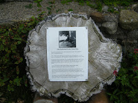
It is believed that there might be a 'plague stone' on the lane - could this be it?
I began by trying to decipher the name itself:

Shaw (sceaga) - copse, small wood
Grim/e - devil
So Grimeshaw = Devil's wood?

This seemed a bit simplistic, so I delved deeper.

Margaret Gelling, in her book Signposts to the Past, says:  "It has been established that Grim meaning the masked one is a nickname for Woden, alluding to the god’s habit of going about in disguise; and the numerous earthworks called Grims Ditch, Grimsdyke, in many parts of the country are believed to contain this nickname, either because they were believed to be the work of the god, or as a vague expression of superstitious awe concerning their origin.


The use of disguise by Woden is inferred from the many instances in which the corresponding Old Norse god Othin behaved in this way. We do not have narratives concerning the Old English gods of the sort which have survived for the ON deities, and there are many dangers in transferring ON information of a much later date to our own relatively brief pagan period. But a major characteristic like this one seems likely to belong to both traditions.

Not all English place names in Grims- are of this origin. Grimr was a common ON personal name and in the areas of England where Danes and Norwegians settled in the 9th and 10th centuries there are such names as Grimsby, Grimethorpe and Grimscoat, which contain this personal name and are of no special archaeological significance. Even in the Danelaw, however, a Grims- name referring to an earthwork is likely to allude to the god."

From the top of the ridge, the proximity to the M6 is visible
A quick internet search told me (grimshaworigin.org) that "The Grimshaw surname originated in Lancashire in the northern part of England, apparently around 1000 A.D. There appear to be few records of Grimshaw family lines for the first 200 to 250 years. However, it is highly probable that the family’s roots are connected to the town of Grimsargh, which is a short distance northeast of Preston. The earliest recorded Grimshaw was Gilbert, father of William Grimshaw, who held the Manor of Grimsargh in thenage in 1242."

I looked for more information on the placename Grimsargh but could only find this, in Wikipedia: "The name Grimsargh is said to derive from an Old Norse name Grímr. One reference lists it as coming from the Domesday Book's Grimesarge, "at the temple of Grímr (a name for Odin.)" I had come full circle.

So what of the place itself? In Ancient Roads and Trackways in Quernmore/Lancaster Phil Hudson says: "There seems no doubt that in the pre-Conquest period there were some well used trackways which would have been part of the communications network for the many small, often defended circular ring-dyke farmsteads found in the area. Butler (l921)** makes reference to a "ridgeway" that passed through Quernmore on a north-south line, following the high scarp via Grimshaw Lane and across the River Lune ford to Halton.


An extension of this ran through Quernmore from Castle O'Trim up to High Cross Moor. This was probably the route, parts of which are still in use, taken by the Earlsgate, recorded in the medieval period. This route, which could be prehistoric in origin, was possibly the basis for the one which was in place during the Roman period when, it is assumed, there was a main road system in the north west created and maintained by the Romans. It is also assumed that the Romans had a network of minor roads or trackways to give access to their industrial sites and potteries on the eastern side of the valley."


From the top of the ridge, one can walk into Lancaster, and I was told the the witches of Pendle walked this way from the prison to their place of execution. From this high ridgeway, they would have known that they were walking in the direction of home, but never to return.

Although it is possible to 'name-check' these witches, overall this is a new facet to historical investigation for me. We do not know who else walked this route, where they lived, where they were going. I am used to having names as a starting point, even if they are only mentioned once or twice in primary sources. I research people, not places. To walk along that track, following the footsteps of countless  unnamed people, was a new experience. This place is most definitely historical, but it is not going to give up its secrets any time soon.


*If you would like to know more about the campaign, visit their Facebook Page
**Butler, M.E. A Survey of the Geographical Factors that have Controlled the History of Lonsdale. Unpublished M.A. University or Liverpool 1921, 3O-4O.

[all photographs by and copyright of the author]

Thursday 1 December 2016

Mrs Gaskell's Tower - Historical Trails & Serendipity

I'm fortunate to live in a part of the world which gives me easy access to many areas of outstanding natural beauty. And I tend to veer away from the obvious spots in the English Lake District to see what else is on my doorstep.

On the northern edge of Morecambe Bay lies a little place called Silverdale, and it was here, at Lindeth Tower, that Elizabeth Gaskell, novelist and biographer of Charlotte Bronte, used to come for her holidays.


As an historian and an author, I love to go wandering along a trail, be it metaphorical or geographical. Mrs Gaskell's Tower had given me a starting point, but she is a literary, rather than historical figure. Little did I know that what started as a 'Victorian' day, would become a day when I got tantalisingly close to the Anglo-Saxons ... 


A pleasant walk down a lane strewn with autumn colours took me down to Jenny Brown's point, where a chimney stands as a reminder of this area's industrial past: 

Photo: Tom Richardson under CC licence
Walking back from the point, I found an old lime kiln which has been reconstructed, fenced off, and given a little placard explaining the history and uses of lime-burning. I also discovered that there was a shipwreck in the area in 1894, when a pleasure yacht, The Matchless, foundered off Jenny Brown's point with the loss of 25 souls.

The English poet Gordon Bottomley (1874-1948) lived in the village and was visited often by his friend, the artist Paul Nash.

Silverdale is noted for its wells, which used to serve the village, and Woodwell is situated, as one might guess, in an area of peaceful woodland.


Photo: Zephyrine Barbarachild
It was a wonderful walk, despite the typical northern weather that day, but I left feeling that I hadn't uncovered everything that Silverdale knew ...

And then I remembered that a while ago I'd read in the local paper about the Silverdale Hoard. Now, I'm an Anglo-Saxon-ist, rather than a Viking-ist, so the Silverdale Hoard didn't initially get my pulse racing in the way that the Staffordshire Hoard is apt to do. And yet, and yet ... something drew me to investigate.

2oo pieces of Viking silver were found by a detectorist in 2011 and have been dated to around the year 900. Of the 27 coins, some are coins of Alfred the Great and some of the Danish king of Northumbria. As with the Staffordshire Hoard, it is assumed that whoever buried this stash was unable, due to the turbulent nature of the times and probably due to loss of limb, or life, or both, to come back and retrieve their retirement fund.

Photo under Wikipedia Commons licence
It's no thing of beauty compared with the ornate goldwork of the other afore-mentioned hoard, but this cache contained a silver bracelet with an unusual combination of Irish, Anglo-Saxon and Carolingian style decoration. Other pieces of jewellery were found as fragments, having been cut up to be used as 'hacksilver', an alternative form of coinage.

One coin in particular was considered note-worthy, inscribed as it was with the name AIRDECONUT, which has been translated as Harthacnut. Since the coin also bears the inscriptions DNS and REX, it has been suggested that this might identify a hitherto unnamed Danish king of Northumbria. The historian in me was interested.

Another coin, a silver penny, was inscribed  ALVVADVS, translated as Aethelwold. The author in me was excited ...

Aethelwold was the son of Alfred the Great's elder brother, King Aethelred. When Alfred died in 899 Aethelwold made a bid for the throne, taking a nun hostage (why? Don't ask me) and holing up in Wimborne, Dorset, where his father was buried, as if to establish that he, and not Alfred's son Edward, had the stronger link to the West-Saxon line of kings. From Wimborne he went to ally himself with the Northumbrian Danes, who acknowledged his claim to the kingship of Wessex. Confident of eventual victory, he must have proceeded to order coins minted in his name. He eventually met his cousin Edward in a remote part of of East-Anglia in 902, at the Battle of the Holme. The rarity of the coin bearing Aethelwold's name perhaps tells you what you need to know about the outcome.

So, from a tower favoured by a Victorian writer, via industry and shipwreck, and an interesting but not initially fascinating buried treasure, I had come, unplanned and unconsciously, to a person whom I feel I 'know' rather well. For you see, a year before this hoard was discovered, I had written a story. It's called To Be a Queen, and it features Alfred the Great, his daughter, her brother, Edward, and their cousin, one Aethelwold, or as I call him, Thelwold.

Those among you who write, and have a penchant for digging, either literally or figuratively, will understand how satisfying it was for me to find out about that tiny little silver penny.

The Aethelwold Silver Penny - image Pubic Domain via Wikipedia


Monday 28 November 2016

Now registered on Blog Lovin'!

This blog is now registered with Blog Lovin'! - this is a wonderful site where you can find lots of great blog content on all manner of topics:

Check out the site

<a href="https://www.bloglovin.com/blog/18356773/?claim=hajyvge6wd2">Follow my blog with Bloglovin</a>

Monday 21 November 2016

Ruthin - From King Arthur to the Beatles in 528 ft

Packing to stay at Ruthin Castle Hotel, my plan was to write a piece about the history of that building, and the medieval castle ruins in the grounds. As history goes, it packs a punch: the 'modern' castle, built in 1828, was owned by the Cornwallis-West family who entertained Lady Randolph Churchill and Edward VII, who in turn entertained his mistresses, including Lilly Langtry and Patsy Cornwallis-West, the chatelaine, whose daughter married the Duke of Westminster.


Outside, the crumbling walls of the original castle bear testament to the onslaught of Owain Glyndwr in 1400. Created originally by Dafydd, brother of the last native prince of Wales, (and who was executed in 1282, the first high-profile recipient of Edward I's hanging drawing and quartering), the castle was granted to Reginald de Grey, ancestor of Lady Jane Grey.

In 1923 Ruthin Castle opened a clinic for "Internal Diseases" run by the wonderfully named Dr Sir Edmund Ivens Spriggs.


So far, so interesting. But stepping through the archway that takes you on a short walk to the market square, I found a beautiful street with astonishing architecture.


And on almost every house, there was a plaque. I hadn't initially realised, because the first house caught my eye only because it was for sale (alas, well out of my reach.)

The house belonged to Sir John Trefor, one-time speaker of the House of Commons. It seems that Sir John lost his position after an accusation of bribery, but my admittedly limited research points to some aspect of decidedly unfair play on the part of his accusers.


I walked on, thinking little more than how lovely and quaint this street was.

But at the end of Strydd Castell (Castle Street) are the buildings that make up the outline of Ruthin Square. Here I found the old court house, now a bank. At first glance, it is notable for having been the first building subjected to attack by Glyndwr. But a plaque on the wall told me a little bit more about its history:

Here, it seems, a Franciscan Friar, Charles Mahoney, was hanged from the gibbet in 1679. Why was a Friar hanged? I discovered that he had been on his way home to Ireland having been preaching in Europe when he was shipwrecked off Milford Haven and tried to make his way north on foot, in hope of finding passage back to Ireland. Alas, he was arrested, charged with being a catholic priest and hung, drawn and quartered.

He'd had the misfortune to be caught at a time when Titus Oates was having success with his anti-catholic 'smear campaign', the Popish Plot.


On the other side of the square is another building (also now a bank).

Outside this bank is a stone where King Arthur reputedly slew Huail, the brother of Gildas the historian.


According to the life of St. Gildas, written in the 12thc by Caradoc of Llancarfan, when Gildas heard the news of his brother's death, he came from Ireland and was able to kiss Arthur and forgive him.

Walking back towards the castle on the other side of the street, I came upon the 'oldest timber-framed building in Wales'. Nantclwyd y Dre dates from 1435/6 and belonged originally to a wealthy weaver named Goronwy ap Madog. The house was extended throughout the centuries and each room inside is decorated to show the different periods during which the house was inhabited.


Work will begin next year to extend the Tudor garden, to which I was allowed access, even though the house was shut for the winter.*


This section of Strydd Castell is a tenth of a mile and by the time you get to Nantclywd y Dre you are almost back at the castle gateway. One last building brings us almost up to date, though. For this is the home occupied until recently by Cynthia Lennon, wife of John. She ran a restaurant in the town for a number of years.

I spoke to a local estate agent who pointed out that Ruthin is practically unique, in that one can drive straight from the countryside into a medieval town centre - there is no modern 'urban sprawl'.


On other streets in Ruthin you will find Siop Nain, a grade II listed building which, as a print shop in 1850, was used to print the Welsh national anthem, for the first time, in Welsh. In the square is a house which was bought by Hugh Myddleton in 1595. He, apparently, provided London with its first clean water supply.

Further down the hill is Ruthin Gaol, the 'only purpose-built Pentonville style prison open to the public as a heritage attraction' (Ruthin Gaol official website.)

Should you wish to venture a little further away from Ruthin, the abbey of Valle Crucis is unusual in having an upper floor dormitory complete with roof and partially remaining inner walls.

At Llangollen is the famous Pontcysyllte aqueduct, an example of the work of engineer Thomas Telford. If you can manage the climb you can ascend 1818 ft up Moel Famau to see the - alas, never completed - Jubilee Tower, planned in honour of George III's golden jubilee in 1810.


I'm never surprised by the wealth of history and historical sites in Wales, but for me, there was a joyous astonishment to discover how much history is contained within that short walk between Ruthin Castle and the town square. 528 ft only, but 16 centuries. I came looking for a medieval castle; I found so much more.

* Since this article first appeared on the EHFA Blog I have returned to the area, so please look out for a future article about Ruthin and the surrounding area.


[All photos taken by and copyright of the author.]

Sunderland Point - Cotton and Slaves


According to Wiki, Sunderland point is "a small village among the marshes, on a windswept peninsula on the mouth of the River Lune and Morecambe Bay". Hardly a description to pique one's interest. But come with me on a little tour of a place that stands immune to the passage of time, beyond the fact that the ships no longer dock here, and the warehouses are now domestic dwellings...


On this virtual tour, your feet will stay dry, but in reality Sunderland Point is only accessible via a single-lane track, which, much like the Island of Lindisfarne, is submerged at high tide. (Although unlike Lindisfarne, it is not an island and is unique in being on the British mainland and yet dependent on the tides for access. The name Sunderland is reputed to mean "sundered from the land").

Local places nearby named 'Catchems' and 'Snatchems' hint at a murky past of Press Gang operation in the area.


Developed as an 'outport' for Lancaster by a Quaker named Robert Lawson in the 18thc, in its heydey, Sunderland Point was rivalled only by London, Bristol and Liverpool. Reputedly, it was the place where the first bale of cotton landed in Britain. 


The stump of the Sunderland point cotton tree is preserved - According to legend, the Cotton Tree grew from a seed imported in a bale of cotton. Although the tree was not grown from a cotton seed, it might actually have come from the USA. It is not a tree normally found in this part of the country, and the female is relatively uncommon in England. It might have been brought as a cutting by one of the sea captains on a return voyage from America.The wood was also used for brake blocks, clogs and even arrows (a clutch was found in The Mary Rose.)

A short, circular walk from the end of the causeway takes you along 'First Terrace', from where you can turn and walk past Upsteps Cottage, where the 'slave Samboo (or Sambo) is said to have been lodging when he died there in 1736. The walk to his grave takes you past the chapel, where if you look closely at the sign you can see that services are 'subject to tides'.


The story goes that Samboo/Sambo was a slave. His grave is out on the middle of the point because as a non-Christian he had to be buried in non-consecrated ground. That much is probably true, but whether he died, as is rumoured, from a broken heart waiting for his master to return from sea, or whether he contracted an illness, is open to conjecture. It seems more likely that he was a crew member of a West Indian trading ship. Reverend James Watson's verse, written in 1796, is still visible on the grave, although the original plaque was, unfortunately, vandalised and had to be recast. It reads:

"Full many a Sand-bird chirps upon the Sod And many a moonlight Elfin round him trips Full many a Summer's sunbeam warms the Clod And many a teeming cloud upon his drips. But still he sleeps - - till the awakening Sounds Of the Archangels's Trump new life impart Then the GREAT JUDGE his approbation founds Not on man's COLOR but his worth of heart."

As you walk away from Sambo's grave, turn round and see a stark reminder of the current largest employer in the area: Heysham Power Station, looming on the horizon. 


Returning to the village you can see across to Glasson Dock, which eventually came to serve Lancaster as Sunderland Point fell into disuse. In 1728, Robert Lawson went bankrupt. By 1830, over 10,000 tons passed through Glasson Dock, most of it taken then to the Lancaster canal, construction of which had begun in 1792.


But reminders of Sunderland Point's heyday remain. Rounding the point, one catches sight of Sunderland Hall, a now slightly faded building of grandeur, dating originally from 1683, but with a 'Colonial' style façade added at a later date.


Walking back along Second Terrace takes you past the old warehouses (pictured at the top of this page) and past walls and gateways that offer glimpses of otherwise hidden gardens. Many of the buildings here are Grade II listed, and the whole village is so untouched by modern building that it was used as a location for the television production of "Ruby in the Smoke".

A final reminder before we leave, is of the capricious nature of the elements. These elegant Georgian buildings testify to more than just their history; all have flood defences - modern technology which must surely be an improvement on the past.


But the village, still inhabited but with a large 'holiday home' population, remains quiet, undisturbed by modern development and has the air, especially 'out of season', of an abandoned film set. To walk here, especially on a quiet day, is to get a real sense of how it must have been centuries ago. But you must imagine the noise and bustle of the great days of the ships' cargo being unloaded into the warehouses. Today, an eerie silence is broken by the sound of seabirds calling, and the fishing boats seem to add to the air of abandonment.


[all photographs taken by and copyright of the author]